H-glaze
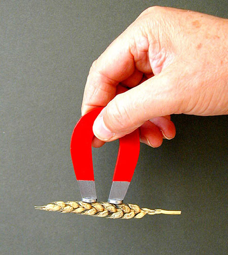
In 1993, two crop circle researchers, Peter Sørensen and Busty Taylor, noticed a distinctive area of stubble in a recently harvested field. It seemed to them that it might have been the site of a crop formation. They reported that sufficient of the crop had been left by the harvester for them to see the outline of the pattern. They also noticed that a brown deposit was on both the flattened remains of the crop and on the ground. It was concentrated in three areas where the crop appeared to have been tightly swirled into circles of about 1 to 2 metres diameter. The deposit varied in thickness. In places it did little more than stain the ground but there were also areas where it was thick enough to have the appearance of having flowed over the ground. The researchers collected samples and it was quickly noticed that the deposit responded to a magnetic field - an observation that led to its being given the name H-glaze. Some samples were sent to Levengood in America who later published a report1. I first became aware of this case in 1999 and, discovering that a few samples remained in the possession of its discoverers, requested that they should be made available for further scientific testing. Taylor supplied me with one small fragment but Sørensen kindly gave me all of the few remaining samples in his possession. I am most grateful for this generosity and the opportunity to bring to public notice the details of this extraordinary case.
The examination of these samples is my present priority. These pages will be updated as soon as new information becomes available.
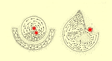
This diagram (which is not to scale) was drawn by Peter Sørensen and depicts the lay of the crop visible even after harvesting. The two main components of the design were approximately 15 metres in diameter and 60 metres apart. The glaze was noticeable coating the limestone soil and the flattened stems, leaves and seed-heads within the swirled regions indicated in red.
The location of the find was a field south of the Yatesbury turn-off on the A4 in Wiltshire, England. The fields in the area are strewn with chalk brought to the surface by ploughing. There are also a great many nodules of flint (flint is almost pure silica and occurs naturally in chalk). On my first visit to the area, I discussed the find with the farmer. He stated that it had rained immediately prior to his noticing the damaged crop and, soon afterwards, he had harvested the field. He only noticed the deposit during harvesting. He had not seen anything like it before and could not offer an explanation for it. There was nothing unusual about that particular area of the field. There were no unusual mineral deposits nor rusting ironwork of any kind in the area. He did all his own spraying and had not emptied out the contents of the tanks of his spraying equipment in the field (Some fertilizers precipitate elemental Iron when exposed to strong sun light).